1800s

Undeveloped landscape
Frequent, low to moderate wildfires were once common in the forested foothills and mountains west and southwest of Denver. But in the mid 1800’s settler, mining and entrepreneur (prospecting, trapping, trading) activity began to replace natural disturbance and indigenous cultural uses as the primary influence on Front Range forests. Since then, fire suppression practices designed to protect human life and property as populations grow, along with historic grazing and mining activities, have impacted the way forests function. Tree densities have increased while forest diversity has decreased, resulting in less resilient forests, higher fuel loads, and more intense fires. Fires like these frequently result in devastating post-fire flooding, erosion, and debris flow events along with many other negative impacts to people, water, and wildlife in this watershed.
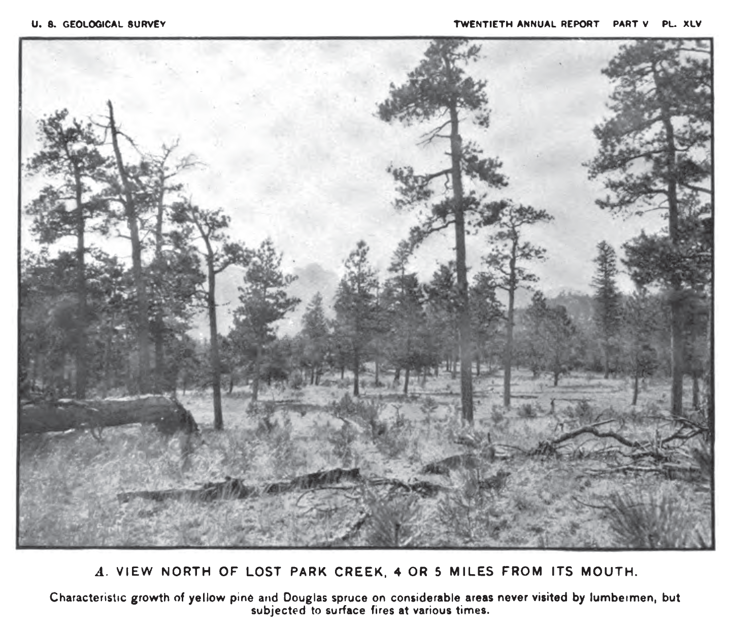
(Photograph taken by John Jack of an area on the Pike National Forest “never visited by lumbermen” (Jack 1900), illustrating the open nature of ponderosa pine stands and a diverse stand structure. Also pictured are snags, downed wood, and an herbaceous understory. Source: GTR-373. Used with permission.)
Early 1900s
Fire supression practices begin
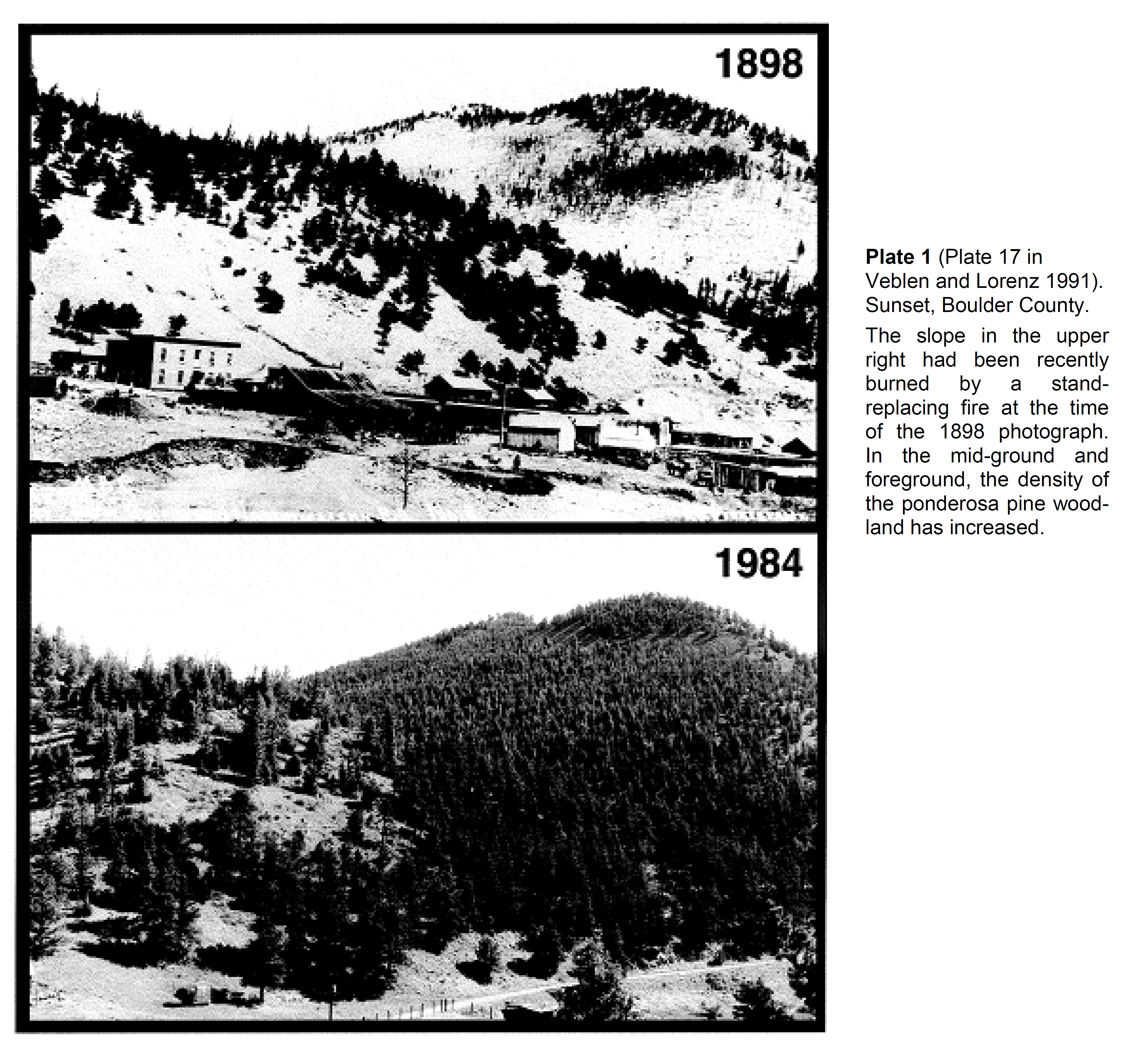
Fire suppression practices designed to protect human life and property, along with growing stationary populations, cattle/horse grazing, and other activities, have impacted the way Colorado grasslands and forests function. Tree densities began to increase while forest diversity decreased. This has resulted in less resilient forests, higher fuel loads, and the loss of wildlife, bird, and beneficial insect habitats, among other impacts.
(Photo-sequence from Veblen and Lorenz (1991) depicting forest conditions in 1898 and again in 1984 near Boulder, CO. Source: GTR-373. Used with permission.)

1983
The Foothills Project is completed
In order to support the growing residential populations and commercial industries, the Foothills Project, which included Foothills Treatment Plant, Waterton Canyon and Strontia Springs Reservoir, was completed. Foothills Treatment Plant treats water from the Upper South Platte watershed for distribution in the Denver area.
(Source: Denver Water Timeline)
May 18, 1996
 Buffalo Creek Fire
Buffalo Creek Fire (human caused) leads to nearly 12,000 acres and 10 dwellings burned.
(Photo source: Denver Water. Used with permission)
July 12, 1996

Flood debris inundates Strontia Springs Reservoir
Two months after the Buffalo Creek Fire, a significant rain event occurs causing major flooding and damages. A million cubic yards of sediment and debris from the burn scar area filled Strontia Springs Reservoir. This is equivalent to 15 years of sedimentation in one single flooding event. Denver Water spent ~$30M in initial clean up. Costs and impacts are still felt nearly 30 years later.
(Photo source: Denver Water. Used with permission)
August 1998
Collaborative publication launching the USP project
The US Forest Service, Colorado State Forest Service, Denver Water Board and Environmental Protection Agency published the Upper South Platte Watershed Protection and Restoration Project report.
June 2000
Hi Meadow Fire
Hi Meadow Fire (human caused) burned 10,500 acres, 51 homes, and seven additional structures.
April 2002
Snaking Fire
Snaking Fire (human caused) burned 2,312 acres and some outbuildings.
May 2002
Schoonover Fire
Schoonover Fire – 3,860 acres and 13 structures, including one bridge, burned after a lightening strike.
June 2002
Hayman Fire
The Hayman Fire, human caused, largest at its time in Colorado, burned 138,00 acres; 132 structures were destroyed and six people died.
2010
Upper South Platte Watershed Assessment
The Natural Resources Conservation Service (NRCS) publishes the Upper South Platte Watershed Rapid Assessment. The NRCS helps private landowners care and make healthy choices for soil, water, air, plants and animal habitats.
March 2012
Lower North Fork Fire & Colorado Division of Fires Prevention and Control (DFPC)
Lower North Fork Fire burned 4,140 acres, 24 structures lost and three people died. In response, the Colorado Division of Fires Prevention and Control (DFPC) was established.
June 23- July 10, 2012
Waldo Canyon Fire
Waldo Canyon Fire in Colorado Springs, 18,247 acres burned, 346 structures were lost and two people died.
June 11 – June 20, 2013
Black Forest Fire
Black Forest Fire, Colorado Springs, 14,280 acres were burned, at least 509 homes destroyed, and two people died.
2015
USPP formally organized
Upper South Platte Partnership (USPP) formally organized. USPP has been planning and implementing collaborative forest health and wildfire mitigation efforts within the watershed landscape since then. The USPP is made up of independent partners working collaboratively for a greater purpose and a greater good for the benefit of the landscape, communities, drinking water supply, and ecosystems.
2019
RMRI selects USPP as a model for collaborative projects
Rocky Mountain Restoration Initiative (RMRI) was founded by the USFS and National Wild Turkey Federation. Due to the efforts of the partnering entities of the USPP, RMRI selected the watershed, along with two other landscapes within Colorado, to showcase in support of increasing pace and scale of accomplishments of collaborative projects.
2020
Largest Colorado Wildfire record surpassed three times in a year
In Colorado, 2020 became a record-smashing year for wildfires. The Haymen fire was surpassed three times over as the largest CO wildfire recorded in modern history. It was surpassed by the Pine Gulch (139,007 acres), East Troublesome (198,312 acres) and Cameron Peak (208,913 acres) fires in sequence.
2021
Most destructive wildfire in Colorado history
Although not the largest number of acres burned, the Marshall Fire (north of the Upper South Platte watershed) in a suburban area surrounded mostly by grasses within Boulder County, became the most destructive wildfire in Colorado history with 6,000 acres burned, 1,084 structures destroyed and two lives lost.
2022
 USPP identified as high-risk landscape
The USPP landscape is included in the original 10 National Wildfire Crisis Strategy (WCS) high‐risk landscapes. The Colorado WCS landscape extends to the north and to the south across 3.6 million acres within Colorado’s Front Range. The Upper South Platte watershed is located at the heart of this Colorado WCS landscape and makes up nearly 1/3 of the total Colorado WCS acreage.
(Image source: Confronting the Wildfire Crisis, USFS 2002)
2023
Wildfire Matters is created as a legislative committee
Colorado’s Wildfire Matters Review Committee was created by the Colorado General Assembly which provides a legislative voice to the values at risk for Colorado watersheds. This was in response to the national effort to address wildfire resilience and confronting the national wildfire crisis as it pertains to Colorado.
